


Antique Maps of Eastern United States Vintage
US$33
Pay in 4 interest-free payments of $8.25
with ![]() .
Learn More
.
.
Learn More
.
Size
This item is sold
Like and save for later
Excellent pre-owned vintage condition (some nips, scratches as shown in pics)
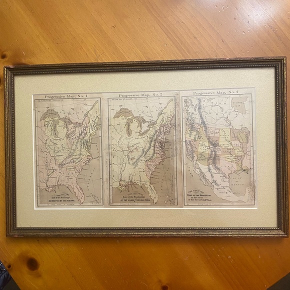
Antique map depicting the eastern United States. Features detailed geographical markings and historical annotations.
The image shows a series of three progressive maps of the United States, likely dating back to the 19th century. The maps illustrate the country's expansion and development over time. The maps are labeled as "Progressive Map, No. 1”, Progressive Map, No. 2," and “Progressive Map, No.4”.
It appears that "Progressive Map, No. 3" is missing from the sequence.
Progressive Map No. 1:
Shows the eastern United States, east of the Mississippi River, with the original 13 colonies and surrounding Native American territories labeled, such as the Cherokee, Shawnee, and Creek nations.
Progressive Map No. 2:
Expands on the first map, showing more of the eastern United States and the Great Lakes region, still focusing on the area east of the Mississippi River.
Progressive Map, No. 4:
Shows the United States, including the territories west of the Mississippi River. It includes California and the Southwest, acquired after the Mexican-American War. The map is labeled "The Country West of the Mississippi at the Close.
Beautiful brown gold frame. Ready to hang!
Approximate Measurements:
Framed: Almost 16”
Almost 10”
Thanks so much for 👀.
Shipping/Discount
Posh Protect: Buyer Protection Policy
Get your order as described or receive your money back. Learn More.


jamiesoden2020
and
one other
like this


Find Similar Listings
About the seller

@greeneyes1383
Last Active: hours ago
Boynton Beach, FL
797
Listings500+
Sold Listings1 day
Avg. Ship time100+
Love NotesAbout the seller
@greeneyes1383
Last Active: hours ago
Boynton Beach, FL
797
Listings500+
Sold Listings1 day
Avg. Ship time100+
Love Notes
Account is under Review
Comment posting is temporarily restricted. Our team will reach out to you shortly. To understand why, select
Learn More.
